Hurricane Dorian, which became a “catastrophic” Category 5 hurricane early Sunday, continues to adjust its path, causing fear and consternation along the Southeastern Atlantic coast.
The National Hurricane Center, in its 11 a.m. ET update Sunday, said the storm’s sustained winds stood at 180 mph (with higher gusts), putting it at the highest possible level of the Saffir–Simpson scale. The storm’s new projected path has it hitting Florida as a major hurricane on Tuesday (as the storm has slowed some in the Atlantic), then moving up the east coast, battering Georgia and the Carolinas.
The cone of uncertainty is still wide, however, so the impact of the storm on coastal cities still cannot be determined. Florida, Georgia, North Carolina and South Carolina have all declared states of emergency as the storm approaches. The NHC is warning people along coastal sections of the Carolinas to expect 5 to 10 inches of rain, with isolated areas getting up to 15 inches.Dorian is “the strongest hurricane in modern records for the Northwestern Bahamas” and will bring “catastrophic conditions [to] the Abacos Islands,” said officials at the NHC.
A Hurricane Watch has been issued for the east coast of Florida from north of Deerfield Beach to the Volusia/Brevard County Line. And a Tropical Storm Watch has been issued for Lake Okeechobee.
The Northwest Bahamas will feel the true wrath of Dorian first. Aside from the winds, the storm is expected to bring 12 to 24 inches of rain, with some isolated areas getting as much as 30 inches, which may cause life-threatening flash floods. Storm surge will raise water levels by as much as 15 to 20 feet above normal tide levels in some areas of the Abaco Islands and Grand Bahama Island.
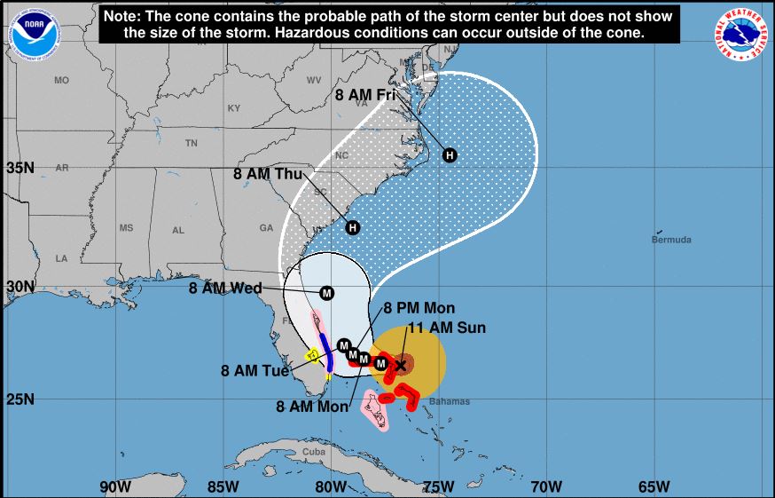
Hurricane force winds currently extend 45 miles from the center of the storm and Dorian has evolved from a Labor Day event to one that will likely last all week. The NHC forecast predicts it will sustain hurricane force winds through at least Friday if it avoids direct landfall.
Dorian, deservedly, is capturing most of meteorologists’ attention right now, but they’re also keeping their eye on a low pressure system that has formed off the African coast. The National Hurricane Center says there’s a 70% chance that will become a named storm within the next five days as it makes its way east across the Atlantic Ocean.
More must-read stories from Fortune:
—Change the World 2019: See which companies made the list
—Corporate America’s most fascinating standoff: The accountant who exposed Madoff vs. GE
—America’s CEOs seek a new purpose for the corporation
—How the world’s biggest companies stay ahead
—What the world’s biggest motorcycle rally reveals about the state of festival food
Subscribe to Fortune’s CEO Daily newsletter for the latest business news and analysis.